In a recent announcement, Montgomery County Fire and Rescue Services (MCFRS) announced the county’s Flood Sensor Partnership, a collaborative effort between the county’s agencies in charge of emergency management, public safety, and storm event preparedness and response, as well as the federal Department of Homeland Security (DHS), to install 35 next-generation IoT flood sensors in the county’s flood-prone areas. Based on real-time monitoring, the flood sensors, which are produced by Intellisense, identify rising flood water levels during storm events and notify officials in advance of flooding. Below is more information according to Montgomery County:
Background: In response to changing climate conditions that are causing more frequent and intense storm events, the DHS Science and Technology Directorate collaborated with scientists, equipment manufacturers, and stormwater management programs across the United States to develop scalable, low-cost flood-sensor networks, which are now deployed in the County as part of this project. In Maryland, riverine and urban flooding is becoming a bigger problem. More urban and riverine flooding occurrences will result from the growing frequency of extreme rainfall events that deliver strong precipitation, and public safety measures will be under more pressure to lessen their effects. According to the 2017 National Climate Assessment, there has been a nationwide increase in heavy rainfall, particularly in the recent three to five decades. The Midwest and Northeast, notably the Mid-Atlantic, have seen the biggest rises.
Under a Cooperative Research and Development Agreement (CRADA), DHS is giving the County free access to all 35 flood sensors, which require little upkeep. The County is in charge of sensor installation and maintenance, data accuracy analysis, and local usage pilots, including long-term operations and procedures.
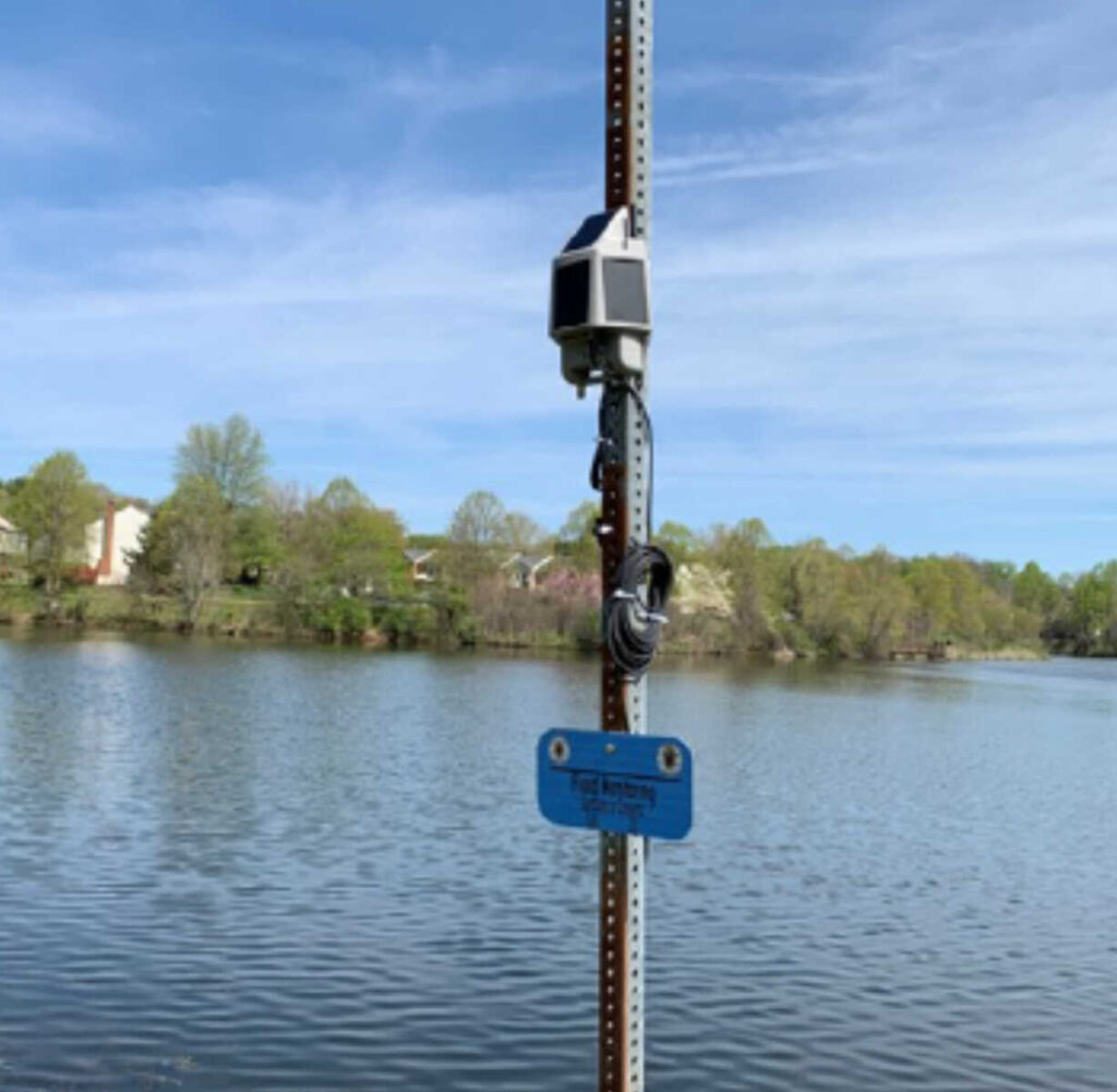
What are the functions of flood sensors?The flood sensors are specifically designed to provide early alerts about floods or high water levels. They automatically detect rising water levels. By protecting vital infrastructure, minimizing property losses, and issuing flood alerts, warnings, and notifications, they will increase community resilience and get communities ready to react.
In what locations are the flood sensors installed?Beginning in June 2022, the flood sensors will be installed at 35 locations chosen by DEP and OEMHS, including 21 low-lying roadways and flood-prone neighborhoods, as well as 14 dams with high or major hazards. The County’s current operations, such as OEMHSs tracking and monitoring water levels at streams and rivers throughout the County using the US Geological Survey (USGS) gauges and DEPs remote monitoring stations that are a part of the current Dam Safety Operations, are enhanced and complemented by these real-time sensors.
Monitoring for Floods in Montgomery County:
- 2200 Brighton Dam Road*
- 25100 Kings Valley Road*
- 26020 Long Corner Road*
- 5410 Griffith Road*
- 8755 Block Gue Road
- Beach Drive & E Stanhope Road
- Beach Drive & Wyndale Avenue
- Burnt Mills at US 29
- Cabin John Creek at Bradley Blvd
- Christie Estates Regional
- Davis Mill Road & Huntmaster Road
- Davis Mill Road & Wildcat Road
- Environ HOA
- Falls Road Dam
- Great Seneca Creek at Brink Road
- Great Seneca Creek at Game Preserve Road
- Gunners Lake Dam
- Hawlings River at 1898 Brighton Dam Road
- Hawlings River at 22000 Zion Road
- Inspiration Lake
- Lake Hallowell
- Lake Nirvana
- Lake Placid
- Lake Whetstone Dam
- Little Seneca Creek at Newcut Road
- Loghouse Road at Macgruder Branch*
- Olney Oaks
- Pine Lake Dam
- Pueblo
- Rattlewood Dam
- Reddy Branch at Brookeville Road
- Rock Creek at Knowles Avenue
- Rock Creek Woods Apartments
- Sligo Creek at Houston Avenue
- Sligo Creek at New Hampshire Avenue
- Sligo Creek at Schuyler Road
- University Blvd Pond
- Vineyard
- W Old Baltimore Road & 10 Mile Creek Road*
- Wheaton Dam
- Wheaton Dam Downstream
* Future Location